Digital mapping research position led to career job for Lyndon Hunter

Digital mapping. Satellite imagery. Statistical analysis. Sound intriguing? Lyndon Hunter sure thinks so. Whether it’s mapping travel plans or mapping weather patterns, Lyndon has been interested in mapping as far back as he can remember.
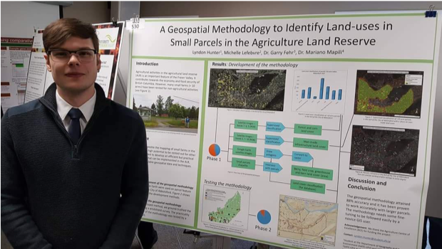
Lyndon had never taken an agriculture course but that didn’t dissuade him from accepting the chance to work as a research assistant (RA) under the direction of Dr. Garry Fehr. “That was a big change. Not just about doing work but learning on the job too,” Lyndon recalls. The project used geospatial methodology to identify land use by focusing on ALR classifications and looking for land misuse, such as truck parking on agricultural land.
Lyndon used remote sensing to determine agricultural and non-agricultural uses.
“Different materials reflect different brightness intensities in the satellite imagery,” he explains.
Lyndon further developed his mapping and analysis software skills using ArcGIS to create digital maps as well as physically visiting small land parcels to confirm the data sets.
“It was challenging for sure, but it wasn’t a bad sort of challenging! I learned how to organize large masses of data in a way people could understand,” Lyndon says.
Far out-weighing the challenges, the position offered beneficial opportunities to collaborate with UFV professors, network with government officials, and meet provincial ministers to discuss agriculture, all of which contributed to his professional development.
“I enjoyed the fact that what I was working on was important to someone else.”
Today, as a UFV alumnus, Lyndon works as a planning technician for the City of Quesnel, responsible for web mapping analysis of properties within the city. He credits his career success to the valuable experience gained as an RA where he “learned by doing.”
“The data that I was working with for the agriculture projects had a lot of the same attributes that I use in my position with the city, making for an easy transition to the workplace.
Lyndon graduated with a BSc degree in physical geography and a certificate in GIS (Geographic Information Systems). Grateful for his involvement in research and working part-time throughout his academic career, Lyndon also graduated student loan-free!
Does Lyndon think other UFV students could springboard their careers by working as research assistants? Absolutely!
“You’ll really find out if you want to work in the field you’re studying. It’s sort of a testing ground. You’ll kind of become an expert in that one specific topic.”
“It was satisfying to be able to match a project to Lyndon’s interests,” noted Gary Fehr, Lydon’s faculty advisor. “And after that, it was Lyndon who used and further developed his classroom skills in a product that government, industry, and other academics value.”


